
SWAT+ Watershed Modeling: Advanced Hydrological Simulation for Climate Impact Assessment
The Soil and Water Assessment Tool Plus (SWAT+) represents a significant evolution in watershed-scale hydrological modeling, offering enhanced capabilities for simulating water quality, sediment transport, and agricultural management practices under changing climate conditions. This next-generation model builds upon decades of SWAT development while introducing modular architecture and improved process representations critical for contemporary environmental research.
Enhanced Landscape Representation
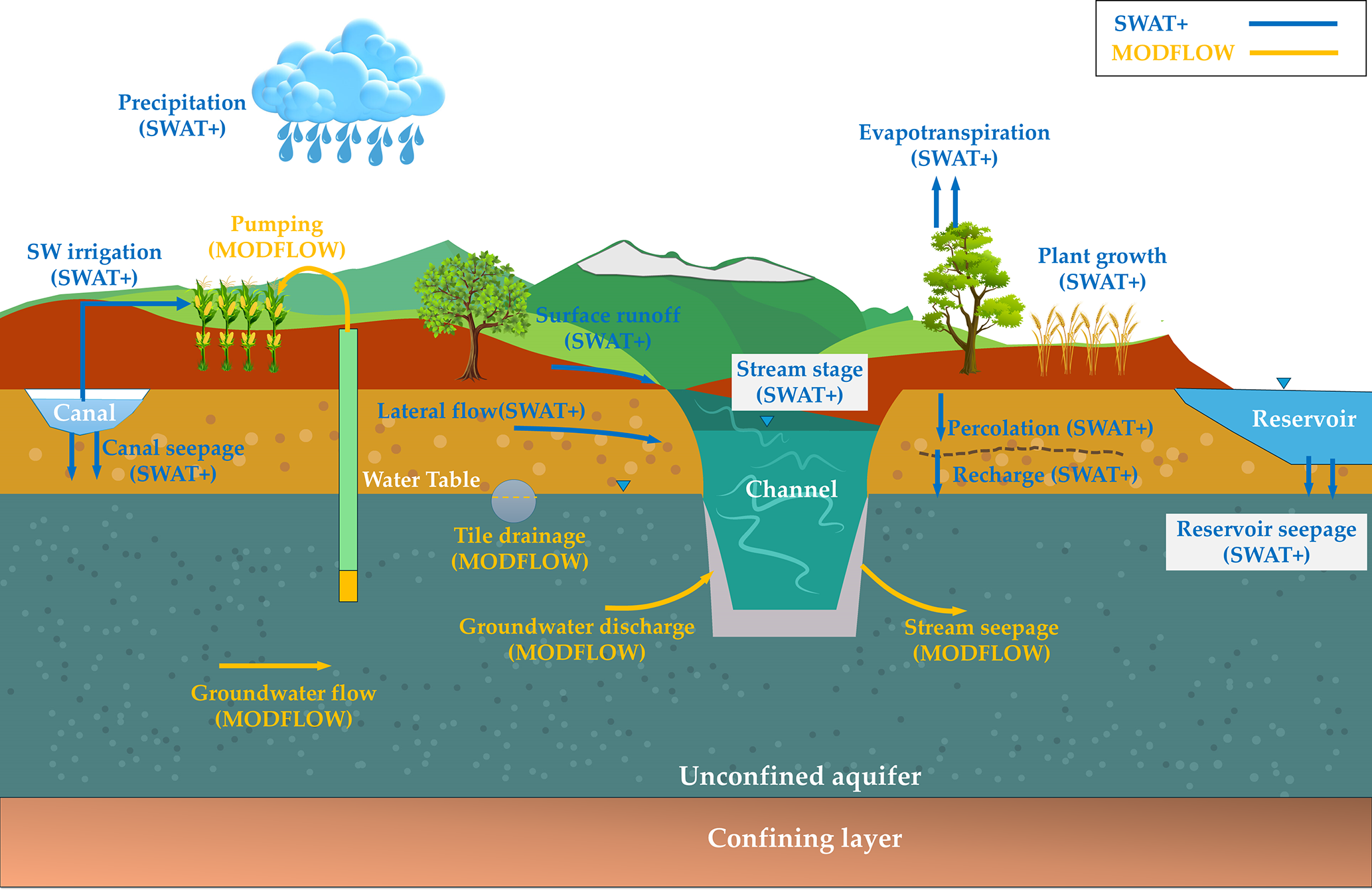
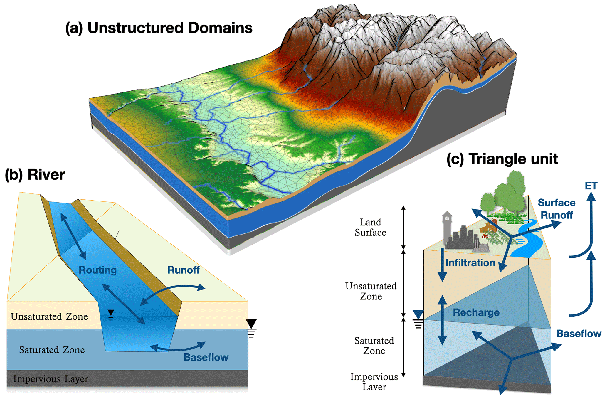
SWAT+ introduces a revolutionary landscape unit (LSU) approach that replaces the traditional hydrologic response unit (HRU) framework. This architectural change enables more realistic spatial connectivity between landscape elements, allowing water, sediment, and nutrients to flow sequentially through the watershed. The LSU structure supports complex routing scenarios where runoff from upland areas can infiltrate into lower landscape positions before reaching stream channels, dramatically improving the model's ability to represent buffer strips, riparian zones, and conservation practices.
The model's flexible spatial discretization accommodates watersheds ranging from small agricultural fields to continental-scale river basins. Users can define landscape units based on topographic position, soil characteristics, land use, and management practices, creating a physically meaningful representation of watershed heterogeneity. This granular control proves essential when evaluating best management practices (BMPs) or assessing the spatial distribution of climate change impacts.

Advanced Climate Change Capabilities
SWAT+ incorporates sophisticated algorithms for processing climate model outputs, including bias correction routines and statistical downscaling methods. The model accepts input from multiple Global Climate Models (GCMs) and Regional Climate Models (RCMs), enabling ensemble-based uncertainty analysis. Built-in CO₂ response functions adjust plant growth and water use efficiency based on atmospheric carbon dioxide concentrations, capturing a critical feedback mechanism often overlooked in traditional hydrological models.
Temperature-dependent process representations extend throughout the model structure. Snowmelt algorithms account for elevation gradients and aspect effects, while soil temperature routines influence decomposition rates, nutrient cycling, and biological activity. These temperature sensitivities make SWAT+ particularly valuable for projecting watershed responses to warming scenarios, especially in snow-dominated or high-latitude regions where climate change impacts manifest most dramatically.
Water Quality and Nutrient Cycling
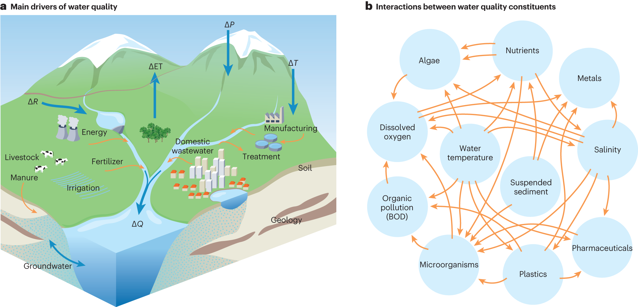
The model's nutrient cycling routines simulate nitrogen and phosphorus transformations through multiple pools and pathways. Organic matter decomposition, mineralization, immobilization, nitrification, and denitrification processes respond dynamically to soil moisture, temperature, and oxygen availability. Phosphorus routines distinguish between labile and stable pools, accounting for sorption-desorption dynamics and the long-term legacy effects of historical fertilizer applications.
SWAT+ includes detailed pesticide fate and transport modules that track parent compounds and metabolites through soil profiles and aquatic systems. Degradation kinetics vary with environmental conditions, while sorption coefficients determine mobility through the soil matrix. These capabilities support regulatory assessments of agricultural chemical impacts on drinking water sources and aquatic ecosystems.
Reservoir and Water Management Operations
The model's reservoir module simulates complex operational rules including flood control, hydropower generation, irrigation supply, and environmental flow requirements. Users can specify target storage levels, release schedules, and priority hierarchies that reflect real-world water management decisions. This functionality proves critical when evaluating climate adaptation strategies or assessing the reliability of water supply systems under future hydrological regimes.
Irrigation scheduling algorithms optimize water application based on soil moisture deficits, crop growth stage, and water availability constraints. The model supports multiple irrigation methods including surface, sprinkler, and drip systems, each with characteristic efficiency parameters and return flow patterns. These features enable detailed analysis of agricultural water use and the effectiveness of irrigation modernization programs.
Model Calibration and Uncertainty Analysis
SWAT+ integrates with multiple calibration frameworks including SWAT-CUP, PEST, and Python-based optimization libraries. The model's modular structure facilitates parameter sensitivity analysis, helping users identify the most influential parameters for their specific application. Multi-objective calibration approaches balance competing performance metrics such as streamflow timing, peak flow magnitude, baseflow recession, and water quality constituent concentrations.
Uncertainty quantification methods range from simple Monte Carlo sampling to sophisticated Bayesian approaches that formally incorporate prior knowledge and observational uncertainty. The model outputs probability distributions rather than single deterministic predictions, providing decision-makers with essential information about the reliability of projected outcomes. This probabilistic framework aligns with contemporary risk assessment methodologies used in climate adaptation planning.
Integration with GIS and Data Platforms
SWAT+ maintains strong integration with QGIS through the QSWAT+ plugin, which automates watershed delineation, subbasin discretization, and landscape unit definition. The plugin leverages high-resolution digital elevation models (DEMs), soil databases, and land use datasets to construct spatially explicit model inputs. Automated workflows reduce setup time while ensuring consistency and reproducibility across modeling studies.
The model interfaces with cloud-based data platforms providing access to global climate datasets, satellite-derived land cover products, and soil property databases. These connections democratize access to high-quality input data, enabling SWAT+ applications in data-sparse regions where traditional field measurements prove logistically challenging or prohibitively expensive.
Applications in Climate Resilience Planning
Water resource managers increasingly rely on SWAT+ projections to inform infrastructure investments and policy decisions. The model quantifies how climate change may alter seasonal water availability, flood frequency, drought duration, and water quality conditions. These insights guide the design of adaptive management strategies including reservoir reoperation, groundwater banking, water reuse systems, and ecosystem restoration projects.
Agricultural stakeholders use SWAT+ to evaluate crop selection, planting dates, and management practices that maintain productivity under changing temperature and precipitation patterns. The model identifies vulnerable regions where current practices become unsustainable and highlights opportunities for climate-smart agriculture that enhances both production and environmental outcomes.
Further Resources
The SWAT+ development team maintains comprehensive documentation at https://swat.tamu.edu/software/plus/, including theoretical descriptions, input file specifications, and tutorial materials. The SWAT literature database contains thousands of peer-reviewed publications demonstrating applications across diverse climatic regions and research questions. Active user forums and annual conferences facilitate knowledge exchange and collaborative problem-solving within the global SWAT community.
For climate change applications specifically, the SWAT+ team provides guidance on selecting appropriate GCM ensembles, implementing bias correction procedures, and interpreting probabilistic projections. These resources help users navigate the complexities of climate impact assessment while maintaining scientific rigor and transparency in their modeling workflows.