
WRF Model: Advanced Numerical Weather Prediction for Climate Research
The Weather Research and Forecasting (WRF) model stands as one of the most sophisticated and widely-adopted mesoscale numerical weather prediction systems in the atmospheric sciences community. Developed through a collaborative partnership between NCAR, NOAA, and other research institutions, WRF provides researchers and operational forecasters with a flexible, portable platform for simulating atmospheric phenomena at scales ranging from meters to thousands of kilometers.
Core Architecture and Capabilities
WRF employs a fully compressible, non-hydrostatic formulation with terrain-following vertical coordinates, making it particularly well-suited for simulating complex atmospheric dynamics over varied topography. The model supports multiple dynamical cores, with the Advanced Research WRF (ARW) core being the most commonly used for research applications. This architecture enables high-resolution simulations of phenomena including severe storms, tropical cyclones, regional climate patterns, and air quality transport.
The model's modular design allows users to select from numerous physics parameterization schemes for processes such as microphysics, cumulus convection, planetary boundary layer dynamics, and radiation transfer. This flexibility enables researchers to optimize configurations for specific applications, whether studying urban heat islands, mountain wave dynamics, or long-term climate projections.

Data Assimilation and Initialization
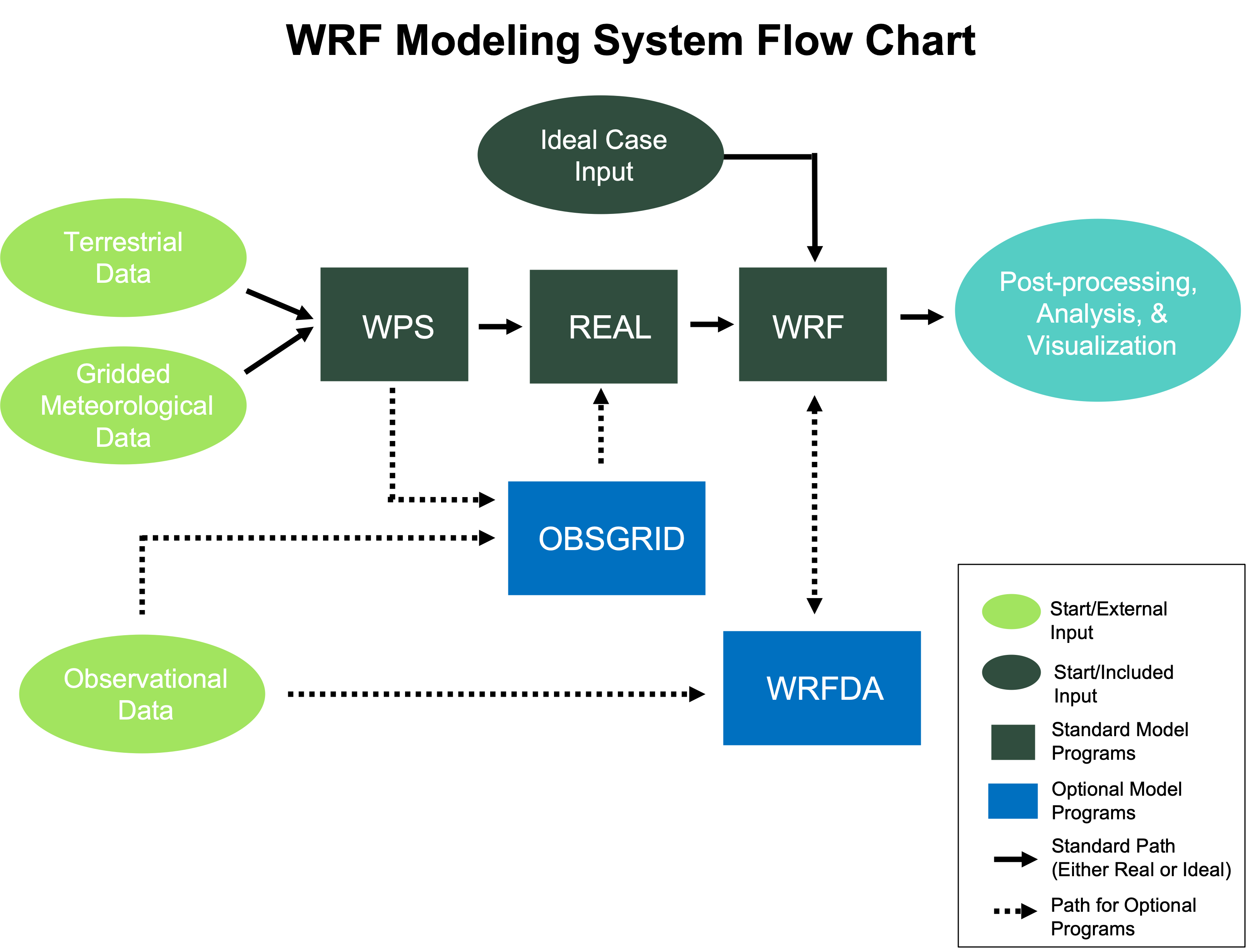
One of WRF's most powerful features is its sophisticated data assimilation capability through the WRF Data Assimilation (WRFDA) system. This component enables the integration of diverse observational data—including satellite retrievals, radar reflectivity, surface stations, and aircraft measurements—into model initial conditions using variational (3DVAR, 4DVAR) or hybrid ensemble-variational methods.
Proper initialization is critical for forecast accuracy. WRF typically ingests boundary conditions from global models such as GFS, ECMWF, or ERA5 reanalysis datasets. The WRF Preprocessing System (WPS) handles domain configuration, terrestrial data interpolation, and meteorological field processing. For climate applications, researchers often employ spectral nudging techniques to maintain consistency with large-scale forcing while allowing mesoscale features to develop freely.
High-Resolution Climate Downscaling
WRF has become the de facto standard for dynamical downscaling of global climate model outputs to regional scales. By nesting high-resolution domains within coarser global model boundaries, researchers can examine how climate change will manifest at local scales—information essential for impact assessments and adaptation planning.
Recent applications have demonstrated WRF's capability to resolve convection-permitting scales (grid spacing ≤4 km) over extended periods, eliminating the need for cumulus parameterization and significantly improving precipitation forecasts. These simulations require substantial computational resources but provide unprecedented detail in representing extreme weather events and their potential changes under future climate scenarios.
Computational Considerations and Performance Optimization
WRF is designed for parallel computing environments and scales efficiently across thousands of processor cores using MPI (Message Passing Interface) and OpenMP threading. Domain decomposition strategies must balance computational load while minimizing communication overhead between processors. For large domains or long simulations, users should carefully consider tile dimensions, I/O frequency, and history output options to optimize performance.
The model supports various compilation options and can leverage GPU acceleration for specific physics schemes, though CPU-based implementations remain most common. Typical production runs for regional climate studies might span decades of simulation time, requiring careful resource planning and checkpoint-restart capabilities to handle inevitable system interruptions.
Integration with Observational Networks and Validation
Rigorous validation against observational data is essential for establishing confidence in WRF simulations. The model output can be directly compared with surface meteorological networks, upper-air soundings, satellite products, and specialized field campaign data. Tools like the Model Evaluation Tools (MET) package provide comprehensive statistical verification capabilities.
For air quality applications, WRF couples seamlessly with the CMAQ (Community Multiscale Air Quality) model through the WRF-CMAQ system, enabling integrated meteorology-chemistry simulations. This coupling is crucial for studying pollution transport, photochemical processes, and the impacts of emissions scenarios on regional air quality.
Future Directions and Community Development
The WRF community continues to advance the model's capabilities through regular releases that incorporate improved physics schemes, enhanced computational efficiency, and expanded functionality. Recent developments include better representation of urban environments, improved land-surface coupling, and advanced turbulence parameterizations for wind energy applications.
The model's open-source nature and extensive documentation have fostered a global user community that contributes to ongoing development and shares best practices. Online tutorials, user forums, and annual workshops provide essential resources for both new and experienced users navigating the complexities of atmospheric modeling.
Further Resources
For those interested in implementing WRF for research or operational applications, the following resources provide comprehensive guidance:
- WRF Users' Guide - Official documentation and tutorials
- NCAR WRF Repository - Source code and development updates
- WRF-Python - Analysis and visualization tools
- WRF Online Tutorial - Step-by-step training materials
The WRF model represents a mature, powerful tool for atmospheric simulation that continues to evolve with the needs of the research and operational forecasting communities. Its combination of physical realism, computational efficiency, and community support ensures its continued relevance in addressing critical questions about weather and climate.