SWAT+ Hydrological Modeling: Simulating Watershed-Scale Water Quality and Agricultural Runoff
Introduction
Agricultural runoff is one of the leading contributors to non-point source water pollution worldwide. Excess nutrients, sediment, and pesticides carried from fields into streams and rivers degrade water quality, harm aquatic ecosystems, and threaten drinking water supplies. For watershed managers, agronomists, and environmental engineers, understanding and predicting these dynamics requires a robust simulation framework — and SWAT+ (Soil and Water Assessment Tool Plus) delivers exactly that.
SWAT+ is the next-generation evolution of the widely used SWAT model, developed by the USDA Agricultural Research Service (USDA-ARS). It provides a physically-based, semi-distributed hydrological model capable of simulating water quantity, water quality, sediment transport, and nutrient cycling at the watershed scale over long time periods. This article explores SWAT+'s core capabilities, its improvements over legacy SWAT, and best practices for applying it to agricultural water quality problems.
What Makes SWAT+ Different from Classic SWAT
The original SWAT model has been in use since the 1990s and has accumulated thousands of peer-reviewed applications. SWAT+ was released to address structural limitations in the original codebase, offering:

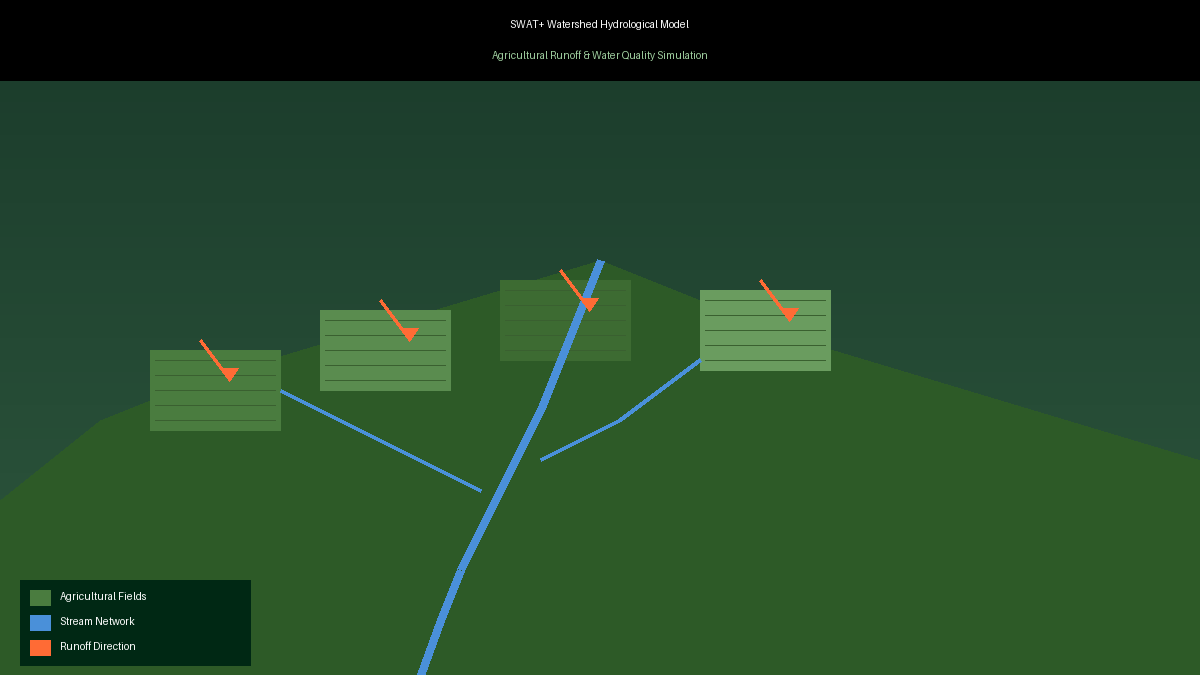
- Flexible spatial connectivity: SWAT+ replaces the rigid HRU (Hydrologic Response Unit) topology with a more flexible landscape unit framework. Water, sediment, and nutrients can now be routed between landscape objects (fields, buffers, wetlands, channels) in user-defined sequences, enabling more realistic representation of field-to-stream pathways.
- Improved routing options: SWAT+ supports variable-rate storage routing and kinematic wave routing for channels, improving accuracy in flashy or tile-drained agricultural watersheds.
- Enhanced management scheduling: The new management scheduler allows complex, conditional operations (e.g., "apply fertilizer only if soil moisture exceeds threshold X"), which is critical for evaluating precision agriculture practices.
- Modular code architecture: The Fortran codebase has been restructured for maintainability and extensibility, making it easier for researchers to add custom process modules.
Core Simulation Capabilities for Agricultural Applications
Water Balance and Runoff Generation
SWAT+ simulates the full terrestrial water balance: precipitation, interception, evapotranspiration (using Penman-Monteith or Hargreaves methods), surface runoff (via SCS Curve Number or Green-Ampt infiltration), lateral flow, and groundwater recharge. For agricultural watersheds, accurate runoff generation is the foundation for all downstream water quality predictions.
Sediment Transport and Erosion
The model uses the Modified Universal Soil Loss Equation (MUSLE) to estimate sediment yield from each landscape unit, then routes sediment through channels using simplified stream power equations. This allows practitioners to identify critical source areas — the small fraction of a watershed that contributes disproportionately to sediment loads — and target conservation practices accordingly.
Nutrient Cycling: Nitrogen and Phosphorus
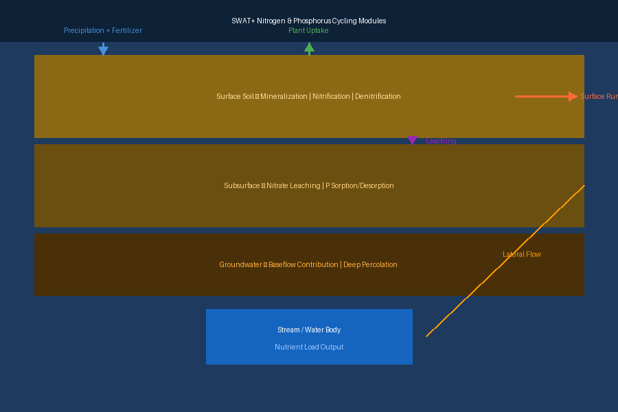
SWAT+ includes detailed nitrogen and phosphorus cycling modules that track:
- Nitrogen: mineralization, nitrification, denitrification, plant uptake, leaching of nitrate, and surface runoff of organic N
- Phosphorus: sorption/desorption dynamics, plant uptake, surface runoff of soluble and particulate P, and subsurface lateral flow
These modules are directly coupled to crop growth and management operations, so the timing of fertilizer applications, tillage events, and cover crop termination all influence nutrient export predictions.
Best Management Practice (BMP) Evaluation
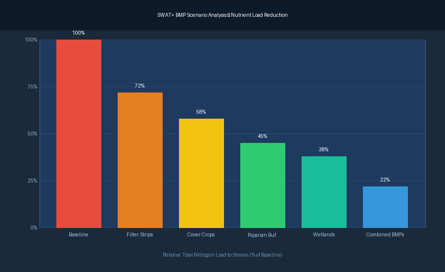
One of SWAT+'s most practical applications is evaluating the effectiveness of agricultural BMPs before field implementation. The model can simulate:
- Filter strips and riparian buffers: Trapping sediment and nutrients before they reach streams
- Constructed wetlands: Attenuating peak flows and removing nitrate via denitrification
- Cover crops: Reducing erosion and nitrogen leaching during fallow periods
- Tile drainage management: Controlled drainage structures that reduce nitrate export
By running scenario comparisons, watershed managers can rank BMPs by cost-effectiveness and target implementation to the highest-impact areas.
Setting Up a SWAT+ Project: Key Steps
- Watershed delineation: Use a Digital Elevation Model (DEM) to delineate the watershed boundary and stream network. The QSWAT+ plugin for QGIS provides a free, open-source interface for this step.
- Land use and soil data: Overlay land use/land cover maps (e.g., NLCD in the US) and soil surveys (e.g., SSURGO) to define HRUs and landscape units.
- Weather inputs: Provide daily precipitation, temperature, solar radiation, wind speed, and relative humidity. SWAT+ can use observed station data or gridded products (e.g., PRISM, ERA5).
- Management operations: Define crop rotations, planting/harvest dates, tillage operations, and fertilizer application schedules for each land use type.
- Calibration and validation: Use observed streamflow and water quality data (e.g., USGS gauge records, NWIS water quality data) to calibrate model parameters. The SWAT+ Toolbox and SWAT-CUP support automated sensitivity analysis and parameter estimation.
Practical Tips for Water Quality Modeling
- Prioritize calibration order: Calibrate hydrology (streamflow) before water quality (sediment, nutrients). Errors in water balance will propagate into all constituent predictions.
- Use the Landscape Unit framework: For watersheds with riparian buffers or wetlands, explicitly represent these features as landscape objects rather than lumping them into HRUs.
- Validate at multiple gauges: If sub-watershed monitoring data are available, validate at interior points to ensure spatial predictions are reliable, not just outlet totals.
- Sensitivity analysis is essential: SWAT+ has hundreds of parameters. Use SWAT-CUP's SUFI-2 or ParaSol algorithms to identify the most influential parameters before manual calibration.
Resources and Further Reading
- SWAT+ Official Documentation: swatplus.org — model theory documentation, input/output file descriptions, and tutorials
- QSWAT+ Plugin: swat.tamu.edu/software/qswat — free QGIS-based interface for watershed setup
- SWAT-CUP: swat.tamu.edu/software/swat-cup — calibration and uncertainty analysis tool
- SWAT Literature Database: swat.tamu.edu/publications — over 4,000 peer-reviewed SWAT applications
- USDA-ARS Grassland, Soil & Water Research Laboratory: ars.usda.gov — primary development team
Conclusion
SWAT+ represents a significant advancement in watershed-scale agricultural simulation, offering the flexibility and physical rigor needed to address today's water quality challenges. Its ability to simulate the full hydrological cycle, coupled with detailed nutrient cycling and BMP evaluation capabilities, makes it an indispensable tool for watershed managers, conservation planners, and agricultural researchers. With free, open-source tooling and an active global user community, SWAT+ is accessible to practitioners at all levels — from graduate researchers to regional planning agencies.