

TransCAD: GIS-Integrated Travel Demand Modeling and Network Analysis for Regional Transportation Planning
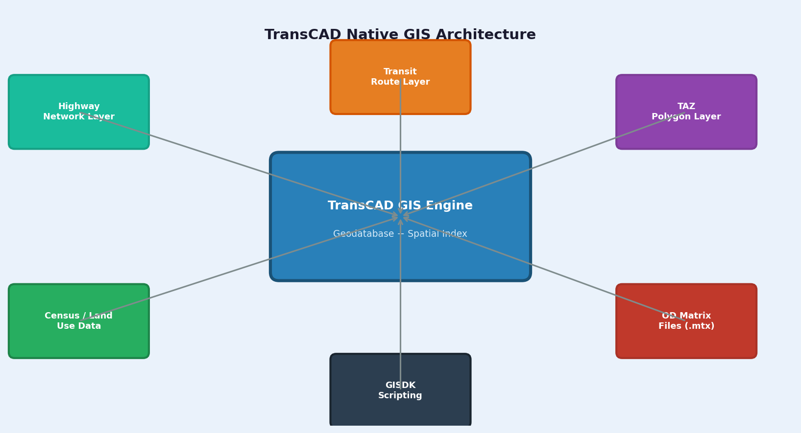
TransCAD, developed by Caliper Corporation, is the only transportation planning software built natively on a Geographic Information System (GIS) engine. Unlike platforms that bolt GIS visualization onto a separate modeling core, TransCAD stores all transportation networks, zone systems, and demand matrices as native GIS layers — enabling seamless spatial analysis, map-based calibration, and direct integration with census and land-use datasets. For metropolitan planning organizations (MPOs), state DOTs, and transit agencies, this architecture eliminates the data translation overhead that plagues multi-tool workflows and makes TransCAD a compelling choice for four-step and activity-based travel demand modeling.
Native GIS Architecture and Network Coding
TransCAD's unified GIS-modeling environment means that every link, node, zone centroid, and transit route is a GIS feature with full attribute tables, spatial indexing, and coordinate reference system support. Network coding begins by importing road centerline data from sources such as HERE, OpenStreetMap, or state GIS clearinghouses directly into the TransCAD geodatabase. Analysts assign functional class, speed, capacity, and turn penalties through attribute joins rather than proprietary import wizards.

The TransCAD Routing Engine supports hierarchical networks with up to 32 user-defined link types and 16 vehicle classes. Turn penalties and prohibited movements are coded as spatial intersection records, allowing bulk edits via SQL-style queries. This approach is particularly efficient for large statewide models where manual turn-penalty coding would be prohibitive.
Zone systems — Traffic Analysis Zones (TAZs) or Transportation Analysis Districts (TADs) — are polygon layers that can be aggregated, disaggregated, or spatially joined to census block groups without leaving the application. Socioeconomic data from the American Community Survey (ACS) or LEHD Origin-Destination Employment Statistics (LODES) can be joined directly to zone polygons, feeding trip generation models without intermediate file exports.
Four-Step Model Implementation
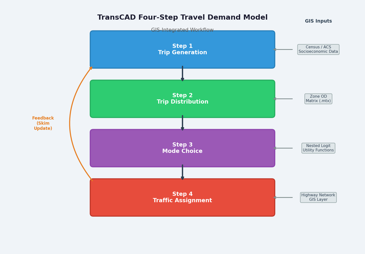
TransCAD implements the classical four-step travel demand model — trip generation, trip distribution, mode choice, and traffic assignment — through a scriptable GISDK (GIS Developer's Kit) macro language. Each step is a callable procedure that reads from and writes to the geodatabase, maintaining a complete audit trail of model runs.
Trip Generation uses cross-classification or regression models applied to zone-level socioeconomic data. Production and attraction rates are stored as lookup tables linked to zone attributes, and the GISDK macro iterates over all zones in a single vectorized pass.
Trip Distribution employs gravity models with gamma or exponential impedance functions. The skim matrix — containing zone-to-zone travel times and costs — is computed from the highway or transit network and stored as a TransCAD matrix file (.mtx), a binary format optimized for large OD matrices. Doubly-constrained Furness (IPF) balancing is built in and typically converges in under 10 iterations for regional models.
Mode Choice is implemented as a nested logit model with utility functions defined in the GISDK script. TransCAD supports up to eight nesting levels, accommodating complex mode hierarchies (drive-alone, shared-ride, transit with walk access, transit with park-and-ride, active modes). Logsums from lower nests feed upper-level destination choice models in activity-based extensions.
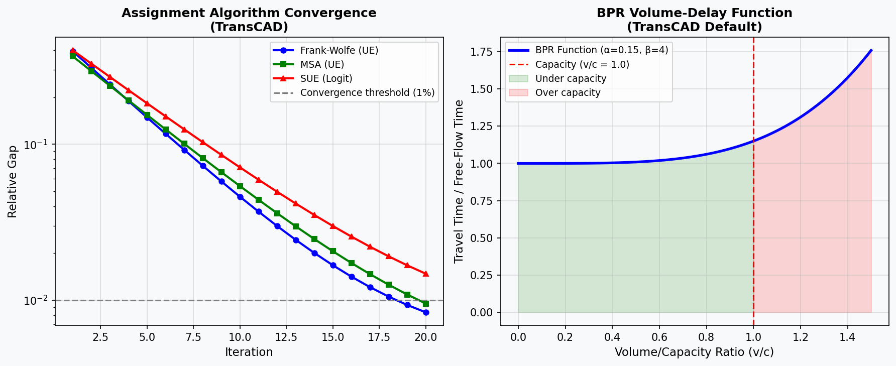
Traffic Assignment offers Wardrop user-equilibrium (UE) via the Frank-Wolfe algorithm, as well as stochastic user equilibrium (SUE) and the more computationally efficient Method of Successive Averages (MSA). For large networks (>100,000 links), TransCAD's parallel assignment engine distributes path-building across available CPU cores, reducing runtime significantly compared to single-threaded solvers.
Transit Network Modeling and Frequency-Based Assignment
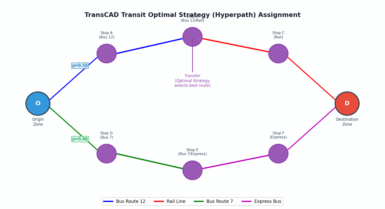
TransCAD's transit module models bus, rail, BRT, and ferry networks as route layers overlaid on the highway network. Headways, fares, dwell times, and vehicle capacities are route attributes. The optimal strategy (hyperpath) assignment algorithm — equivalent to the Spiess-Florian method — assigns transit demand by minimizing expected travel time across all feasible route combinations, correctly handling frequency-based services where passengers do not follow fixed schedules.
Walk and drive access links connect zone centroids to transit stops, with maximum walk distances enforced as spatial buffers. Park-and-ride lots are modeled as intermediate nodes with capacity constraints, enabling realistic representation of suburban commuter behavior.
Calibration and Validation Workflow
Model validation in TransCAD follows the standard FHWA/TRB guidelines: screenline volume comparisons, GEH statistic checks (GEH < 5 for ≥85% of links), and VMT validation by functional class. TransCAD's Select Link Analysis tool identifies the origin-destination pairs contributing to volume on any link — essential for diagnosing assignment anomalies on screenlines or bridge crossings.
The Matrix Calculator and Procedure Manager support iterative feedback loops between trip distribution and assignment (equilibrating travel times), which is required for NEPA-level conformity analyses. Scenario management is handled through project files that snapshot all input matrices, network attributes, and model parameters, enabling reproducible before/after comparisons for alternatives analysis.
GISDK Scripting and Automation
The GISDK macro language is TransCAD's primary automation interface. Scripts can orchestrate complete model runs — from network skimming through assignment — with logging, error handling, and conditional branching. For agencies running daily or weekly model updates with new traffic count data, GISDK scripts can automate count import, network attribute updates, and validation report generation.
TransCAD also exposes a COM automation interface compatible with Python (via win32com) and R, enabling integration with statistical packages for advanced mode choice estimation (e.g., using the mlogit package in R) or machine-learning-based trip generation models.
Practical Considerations
TransCAD is licensed per workstation with optional network license servers for agency-wide deployment. The software runs on Windows only; Linux/macOS users must rely on virtual machines or remote desktop environments. For very large statewide models (>500,000 zones), memory management requires careful matrix partitioning, as TransCAD loads full OD matrices into RAM during assignment.
Documentation is comprehensive, with Caliper providing detailed user guides, GISDK reference manuals, and a library of example models. The user community, while smaller than VISSIM or VISUM, is active through the Caliper user forum and annual Transportation Research Board (TRB) sessions.