
CityScope: Interactive Urban Planning and Smart City Simulation Platform
CityScope, developed by the City Science group at the MIT Media Lab, stands as a pioneering interactive platform designed to revolutionize urban planning and spatial design challenges. It represents a significant departure from traditional, often slow and bureaucratic, urban planning processes by integrating data analytics, computation, visualization methods, and an intuitive, human-centric interface.
Overview and Vision
The project encompasses a diverse array of tangible and digital tools, ranging from sophisticated simulations that quantify the impact of disruptive urban interventions to robust community engagement systems. Deployed globally, CityScope aims to make urban planning more accessible, data-driven, and
participatory, fostering better decision-making for a wide range of stakeholders.
The fundamental premise behind CityScope is to address the growing complexities and rapid pace of urbanization, which often render traditional planning methods insufficient. Challenges such as immigration, climate change, technological disruptions, inequality, and public health concerns demand a more agile and evidence-based approach to urban development. CityScope champions a new urban
process that seamlessly couples data-driven and evidence-based decision-making with human-centric and participatory planning.

Core Philosophy
Ariel Noyman, a key researcher at MIT involved with CityScope, highlights the increasing complexity of urban planning requirements, exemplified by the dramatic growth of building code legislation complexity over time. This complexity often leads to top-down, slow, and bureaucratic processes. City‐
Scope seeks to counteract this by enabling truly participatory urban planning and meaningful co-designing with citizens, regardless of their technical or design expertise.
The platform strives to create an intuitive experience, recognizing that users may not possess expert knowledge of the underlying simulation models. This approach makes complex urban data and simulations physically interactive and accessible to diverse stakeholders.
Key Features and Components
CityScope’s innovative approach is built upon a sophisticated integration of hardware, software, human interface design, cloud computation, and “big data” variants. Its core features can be broadly cat‐
egorized into its tangible user interfaces, digital backend, and its four primary competencies: Insight, Transformation, Prediction, and Consensus.
Tangible User Interfaces (TUIs)
A hallmark of CityScope is its use of tangible interfaces, making complex urban data and simulations physically interactive and accessible.
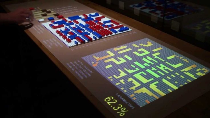
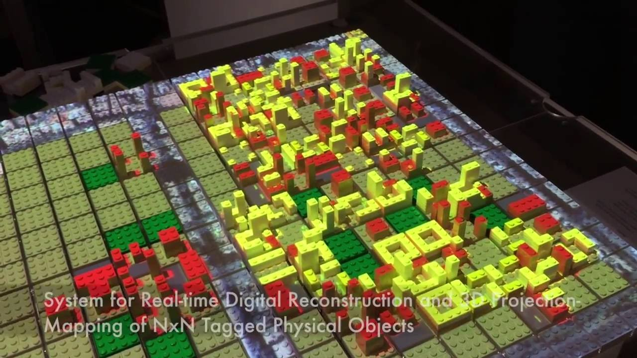
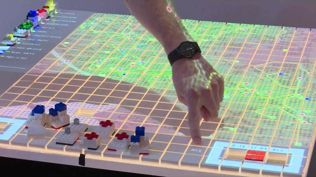
LEGO Bricks and Physical Models: CityScope often utilizes special LEGO bricks on a tabletop to represent urban elements such as residential buildings, parks, or roads. These physical models can represent existing neighborhoods, cities, or regions. The use of familiar materials like LEGOs invites citizens with little to no technical or design experience to interact with proposed projects.
Optical Tags and Computer Vision: Each LEGO piece is assigned a user-determined variable (e.g., “200-unit residential building,” “10-acre park,” “4-lane road”). A special chip or optical tag within each LEGO piece communicates with overhead projectors and computer vision systems. This allows the system to automatically detect, scan, and digitize movements and configurations made by users.
Augmented Reality Projection Mapping: Overhead projectors beam color-coded metrics and other layers of information directly onto the physical LEGO model. As components are modified (moved, removed, or inserted), the projectors instantly update the visual feedback, showing the quantifiable impact of each decision. For instance, placing a residential building might change the color of a street to indicate increased traffic density.
Specialized Prototypes:
- CityScope “Scout”: Transforms any tabletop into a canvas for land use planning, enabling rapid prototyping with real-time evaluation
- CityScope “Reconfigure”: Allows users to edit a digital model by manipulating physical abstractions of building typologies
- Tangible Interactive Matrix (TIM): A rapid prototyping environment for data matrices, using optically tagged LEGO objects, computer vision, and 3D projection mapping
Digital Platform and Backend
Behind the tangible interface lies a powerful digital infrastructure:
Data Analytics and Computation: CityScope leverages advanced data analytics and computational methods to process urban data and run simulations.
Cloud Computation and CityIO: The platform utilizes cloud computing, allowing configurations and data from physical models to be uploaded to a cloud server and viewed from the web. CityIO serves as an API that facilitates data exchange and integration.
Algorithmic Analysis and Predictive Simulation: CityScope supplies algorithmic analysis and predictive simulation to planners and decision-makers throughout various development stages of an urban design endeavor, including assessing performance regarding environmental and spatial impact.
Agent-Based Modeling: For prediction capabilities, CityScope employs agent-based modeling to simulate human interactions and derive use patterns for proposed designs.
GIS Data Integration: GIS data is used to create “LEGO-tized,” 3-dimensional representations of existing urban areas, which are then augmented with layers of information via projection mapping. Examples include mobility systems, Google Satellite imagery, solar insulation, Twitter user activity, and windflow simulation.
Four Primary Competencies
CityScope has developed four primary competencies over the past decade:
1. Insight (CityScope as an Urban Observatory)
Functionality: CityScope overlays layers of data on 3D models to understand urban movement dynamics and human behavior based on existing data. It provides real-time spatial data and urban
dynamics analytics.
Application Example: During the COVID-19 pandemic, this approach was used to identify which forms of urban congregation posed higher risks. By overlaying data on COVID-19 cases, individual location data, and urban activities/amenities, CityScope could decipher which activities contributed most
to rising case counts. This granular insight allowed cities to tailor confinement strategies and intervene in key public spaces to limit human-to-human contact, avoiding full metropolitan lockdowns.
2. Transformation (CityScope as an Iterative, Collaborative, and
Real-Time Urban Human-Computer Interaction System)
Functionality: CityScope enables quantification and experimentation around urban transformation. It “codifies the building code,” turning complex regulations into computational units of analysis against which proposed urban designs can be benchmarked. It estimates the impacts of new developments on
key performance indicators (KPIs) such as density, diversity, and proximity.
Application Example: In 2018, Hamburg, Germany, utilized CityScope to evaluate proposals for an urban redevelopment project related to its bid to host the 2024 Olympic Games. CityScope provided a data-driven way to assess the coherence of designs with current building laws and their potential im‐
pacts.
3. Prediction (CityScope for Urban Forecasting and Simulation)
Functionality: CityScope’s prediction capabilities allow cities to test urban designs and evaluate their utility before implementation, a significant advantage over traditional practices where prototyping often occurs only after construction. It uses agent-based modeling to simulate human interactions and
derive use patterns for proposed designs.
Application Examples:
- Transportation Planning in Hamburg: CityScope was used to optimize aspects of transportation planning by modeling how new transport hubs affect agent movement within the city
- Champs-Élysées Revitalization (Paris): The platform estimated how revitalization plans would
affect how people use the space
- Andorra Tourism Flows: CityScope was used for descriptive visualization of Origin-Destination (OD) Matrices derived from call detail record (CDR) data
- Land Use Transportation Simulator: Adjusts the balance of residential and non-residential land use to analyze effects on trip generation, road congestion, and parking demand
4. Consensus (CityScope for Collaborative Decision-Making)
Functionality: The intuitive, tangible interface invites non-expert citizens to interact with proposed projects and co-produce viable solutions. This shifts urban planning conversations from top-down, technical, and design-focused to bottom-up, accessible, and action-oriented. It helps build agency among those traditionally excluded from the urban process.
Application Example: The “FindingPlaces” project in Hamburg, commissioned by the city, engaged the public to select 161 viable sites for integrated refugee housing. CityScope mediated the process, transforming potential NIMBY-ism (Not In My Backyard) into a “yes we can” attitude.
Applications and Real-World Deployments
CityScope has been deployed in various contexts globally, demonstrating its versatility and impact across different urban challenges:
Urban Design Competitions
The platform serves as a digital instrument for real-time analysis and decision-support in urban design competitions. It focuses on early-stage design proposals, assessing their environmental and spatial impact iteratively. It supports both planners developing proposals and competition juries evaluating
them.
Zoning and Building Legislation
CityScope is well-suited to model the physical effects of zoning and building regulations. By tagging LEGO bricks with scaled metrics of population density, land use, and access to amenities, it drastically increases efficiency for planners modifying regulations, architects designing within them, and
laypersons understanding rule changes.
Kendall Square Zoning Playground: A student team leveraged CityScope to create a “Playground” that empowers non-expert stakeholders to experiment with form-based zoning. The platform provides feedback when user input violates zoning restrictions but does not prohibit such interventions, encouraging exploration.
Transportation Systems Planning
Boston Bus Rapid Transit (BRT): The Mobility Futures Collaborative at MIT DUSP and the Changing Places group developed interactive tools using CityScope to better communicate the possible impacts of new transit systems.
Pedestrian Simulation (Singapore): MIT Media Lab collaborated with the Singapore Centre for Liveable Cities to develop a simulation for pedestrian activity, modeling the relationship between urban parameters like land use, mobility, livability, sustainability, and innovation in real-time.
Last-Mile Logistics and Supply Chain Management
CityScope models last-mile delivery systems at citywide and regional levels, providing interactive displays of real-time traffic and logistics data. This is valuable for companies focused on speedy deliveries, pushing for near-perfect efficiencies. It can also model the supply chain of an entire industry,
quantifying the amount of goods moving globally and facilitating research into environmental effects of traffic from consumer goods.
Community Engagement and Public Participation
Public Meetings: CityScope fundamentally alters the effectiveness of public meetings regarding zoning or building projects by allowing the public to easily interact with the physical laws of their city. This exponentially increases their understanding of a decision’s interrelated effects, informing their
opinions or votes to a level previously unavailable.
Riyadh Workshop: A workshop in Saudi Arabia with the Riyadh Development Authority tested a new CityScope platform version. Teams competed to develop redevelopment proposals for a neighborhood, demonstrating rapid prototyping and collaborative design.
Guadalajara Public Safety: CityScope has been used for crowd-sourced mapping of public safety in Guadalajara.
Specific City Implementations
Hamburg, Germany: A 4-square-meter urban model of Hamburg-Rothenburgsort was built using LEGO bricks and traditional materials. Optically tagged LEGO bricks representing different building types visually reveal changes in real-time via color-coded projections, estimating variables like walkability, access to jobs, housing, or open space.
Andorra: A unique CityScope implementation for Andorra emphasizes tourism, energy, and traffic congestion, utilizing call detail record (CDR) data for tourism flow analysis.
Champs-Élysées (Paris): CityScope is an interactive platform used to improve decision-making
related to the revitalization of the Champs Élysées.
Volpe (Cambridge, MA): CityScope Volpe demonstrates most of the urban planning, analysis, and prediction features developed for the project.
China Deployments: Efforts are underway to deploy AR Decision Support Tools with cloud-based API in Chinese developing cities.
Best Practices and Implementation Guidelines
Understanding the Basics
For new users and cities interested in implementing CityScope, several best practices have emerged:
Clear Communication of Models: To avoid pushback due to a lack of understanding, it is crucial to clearly communicate the underlying models used to citizen participants.
Long-Term Partnerships with Cities: Establishing “CityLabs” ensures that cities can maximize the setup overhead associated with implementing CityScope. This also allows the platform and its objectives to evolve with the changing needs of the city.
Robust and Easy-to-Connect Data Pipelines: Encouraging participating cities to provide robust and easily accessible data pipelines is essential for greater portability of the CityScope platform and a wider proliferation of truly participatory and citizen-centered urban design.
Technical Implementation
Hardware Setup: The basic CityScope setup requires:
- Overhead projectors for augmented reality projection mapping
- Computer vision systems for optical tag recognition
- Physical modeling materials (LEGO bricks with optical tags)
- Computing infrastructure for real-time simulation
Software Integration: CityScope relies on: - CityIO API for data exchange and cloud integration
- Agent-based modeling engines for simulation
- Computer vision algorithms for real-time tracking
- Web-based interfaces for remote access and collaboration
Data Requirements: Successful implementation requires: - GIS data for base mapping
- Real-time urban data feeds (traffic, demographics, environmental)
- Historical data for model calibration and validation
- Regulatory and zoning information
Stakeholder Engagement
Multi-Stakeholder Approach: CityScope works best when it brings together diverse stakeholders including:
- Urban planners and designers
- City officials and policymakers
- Community members and residents
- Technical experts and researchers
- Private sector partners
Training and Capacity Building: Successful deployment requires: - Training sessions for city staff and planners
- Community workshops for citizen engagement
- Technical support for ongoing maintenance
- Documentation and knowledge transfer
Future Directions and Innovations
Technological Advancements
CityScope continues to evolve with emerging technologies:
AI Integration: Incorporating machine learning and artificial intelligence to enhance prediction capabilities and automate certain aspects of urban analysis.
Enhanced Visualization: Developing more sophisticated augmented and virtual reality interfaces for immersive urban planning experiences.
IoT Integration: Connecting with Internet of Things sensors and smart city infrastructure for real-time data integration.
Mobile Applications: Developing smartphone and tablet applications to extend CityScope’s reach and accessibility.
Methodological Improvements
Improved Modeling: Enhancing the accuracy and sophistication of urban simulation models, including better representation of complex urban dynamics.
Scalability: Developing approaches to scale CityScope from neighborhood-level to city-wide and regional applications.
Standardization: Creating standardized protocols and interfaces to facilitate broader adoption and interoperability.
Global Expansion
International Partnerships: Expanding CityScope deployments to cities worldwide, adapting to different cultural, regulatory, and technical contexts.
Capacity Building: Developing training programs and educational resources to build global capacity for participatory urban planning.
Open Source Development: Continuing to develop open-source components to enable broader community contribution and innovation.
Impact and Outcomes
CityScope’s development and deployment have shown its capacity to support, enhance, and occasionally replace traditional urban decision-making processes, impacting both the process itself and its outcomes. Its ability to quickly and simply model the effects of large-scale urban-planning decisions using
augmented reality makes it a powerful and accessible tool.
The project continues to evolve, with documentation and software being works in progress, indicating ongoing innovation and refinement. The ultimate beauty of CityScope lies in its ease of understanding and simplicity of use, making it a promising example of technology that adapts to human actions rather than the other way around.
Conclusion
CityScope represents a paradigm shift in urban planning, moving from traditional top-down approaches to participatory, data-driven, and interactive methodologies. By combining tangible interfaces with sophisticated simulation capabilities, it democratizes urban planning and enables more inclusive, informed, and effective decision-making.
The platform’s success across diverse global contexts demonstrates its adaptability and potential for widespread impact. As cities face increasingly complex challenges related to growth, sustainability, and social equity, tools like CityScope provide essential capabilities for creating more livable, resilient, and inclusive urban environments.
The continued development and refinement of CityScope, along with its growing global community of users and contributors, positions it as a leading platform for the future of urban planning and smart city development. Its emphasis on human-centered design, participatory engagement, and real-time feedback creates new possibilities for how cities can be planned, designed, and managed in the 21st century.
References
• MIT Media Lab CityScope Project (https://www.media.mit.edu/projects/cityscope/overview/)
• CityScope Official Website (https://cityscope.media.mit.edu/)
• MIT City Science Group (https://www.media.mit.edu/groups/city-science/overview/)
• CityScope Research Publications (https://www.media.mit.edu/publications/cityscope/)
• Urban AI and CityScope (https://medium.com/urban-ai/cityscope-from-smart-cities-to-street-know‐ledge-95d51cb322f4)